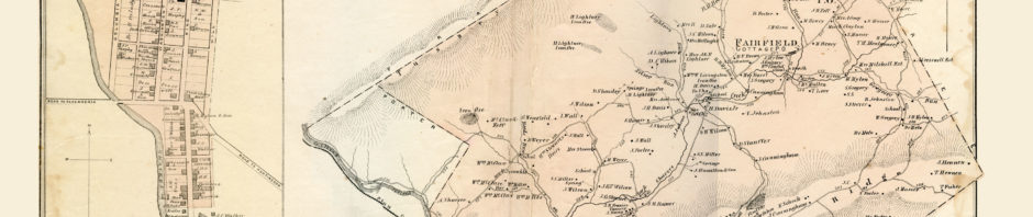
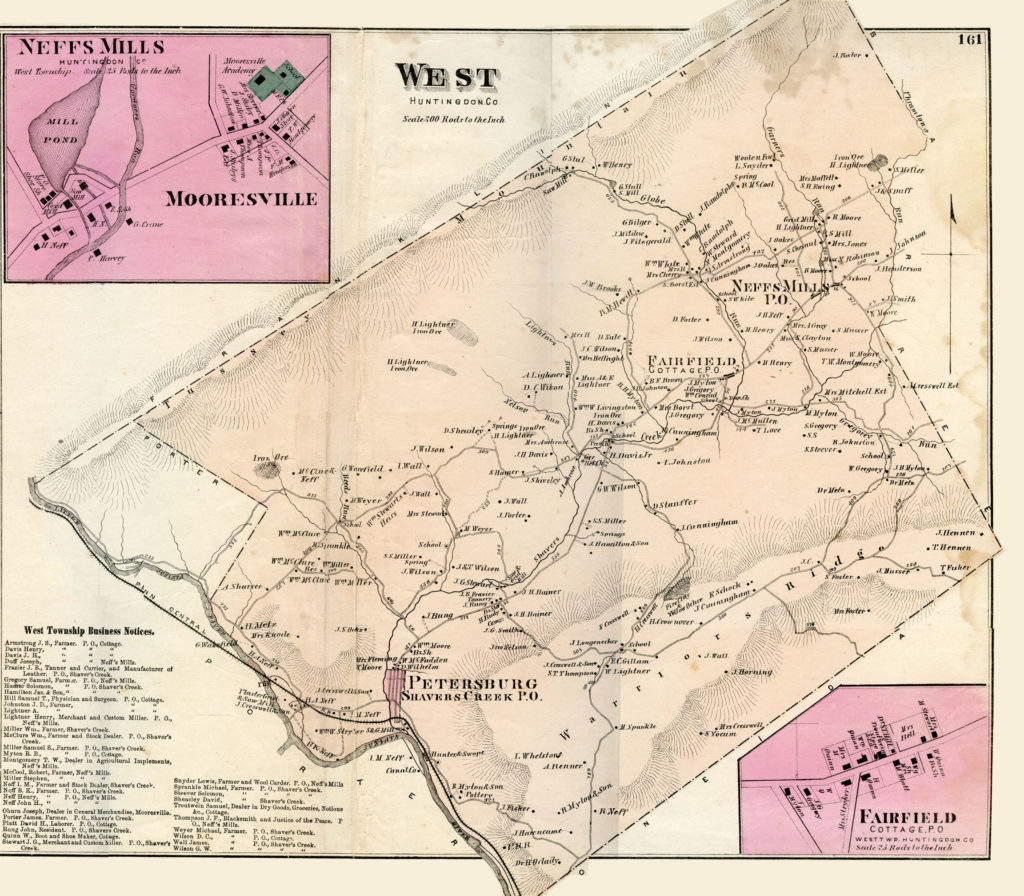
The map of West Township is from Pomeroy’s Atlas of Blair & Huntingdon Counties (1873) and shows its area before the division that created Logan Township in 1878.
In the 1890’s, Prof. Robert A. Ramsey, Altoona, wrote a series of articles for The Semi-Weekly News on the history of Shaver’s Creek and Stone Creek Valleys. Ramsey’s original spelling and capitalization has been retained in this transcription from the newspaper copy.
WEST TOWNSHIP
Another of Prof. Ramsey’s Interesting Chapters on Local History
This township was formed from Barree in 1796, and for many years thereafter was called West Barree. It lies entirely in the Shaver’s Creek valley and contains about thirty-four square miles.
Its surroundings are Franklin township and Centre county on the north, Barree on the east, Oneida on the south, and Logan on the west.
West township formerly embraced the territory that is now included in Logan and part of that within the bounds of Oneida. The whole of the southern line is along the summit of Warrior Ridge, while the northern line is on the crest of Tussey’s mountain.
EARLY SETTLERS
John and James Dickey settled near Shaver’s creek, not far from where Fairfield now stands, in 1764. Several improvements were made in various parts of the township previous to 1769. The tract of land, now divided into two farms, and owned by the heirs of Thomas and James Hennen, was improved before the year 1771, by James Hennen, great-grandfather of the present owners. James Hennen came from Cumberland county, and on account of the frequent visits of the Indians in the vicinity, the family left the improvement once, if not twice, and found a place of refuge in the Cumberland Valley, but returned after danger had passed.
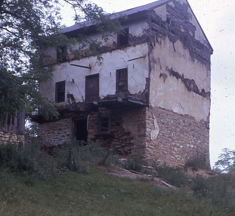
This 3-story plastered log house was the Hennen homestead, probably built after their return from seeking refuge in Cumberland County.
A farm near the head of Chilcoat’s hollow was improved about 1773.
The farm owned by Hon. T.W. Montgomery was purchased and improved by his paternal grandfather in 1794 or 95.
Other early settlers in this section were Andersons, Ewings, Fosters, Mytons, Lightners and McCormicks.
At the breaking out of the Revolution there came a time of distress for those who had ventured to this part of the country; to insure them some means of protection, a blockhouse, or fort, was built by Alexander McCormick a short distance northwest of Neff’s Mills. There is no proof that there ever was an attack made upon this place of defense, but it is evident that its existence prevented the skulking scalp-hunters from committing any serious depredations in its locality.
The abduction of Mary [actually Betsey] McCormick and Kate Ewing by the Indians took place during the month of October 1782, and at a time when it was thought there were no “red skins” in the neighborhood. [See “Preserving Old Cemeteries” under Research Projects for more of this story.]
STREAMS
Shaver’s creek enters the township from Barree, and after flowing through a broad and beautiful valley, gathering the drainage from Tussey’s mountain on the north and from Warrior Ridge on the south, enters Logan township on its westward course to the Juniata.
Phrampton’s run rises in the western corner of Barree, a very short distance from the West township line and separates the two townships from near its source, until it flows into Shaver’s creek, a short distance east of Mooresville. In its course, it flows through the farms of Miller Bros., Wesley Gregory, Howard Hutchison, Miles Henderson, John Kidder, and Sheridan Moore.
Gardner’s [Garner’s] run rises in Harry’s valley and is somewhat serpentine in its course, though its general direction is south, and flows into Shaver’s creek about one and a half miles below Neff’s Mills.
Globe run rises at the base of Tussey’s mountain in Diamond Valley, and after passing through the gap in Leading Ridge, flows southeast and enters Shaver’s creek near Fairfield. Wilson’s run rises along the foot of Leading Ridge; flowing nearly south it enters Shaver’s creek a short distance above the “Bridge.” Lightner’s run rises in the western corner of the township, flows south into the creek below the “Bridge.”
Gregory’s run, the only stream of any pretensions on the south side of the creek, rises on the farm of Dr. Metz at the foot of Warrior Ridge, and runs northwest and enters Shaver’s creek at D. Ross Gregory’s farm.
THE SOIL
While there is some very productive land on the north side of Shaver’s creek, there are a few acres that would not bear reckless usage and yield a paying crop.
There is a streak of red shale crosses the township in a westerly direction, coming to the surface on the public road between Robert Johnston’s and Ross Gregory’s and appearing again on the north side of the public highway about sixty rods west of Fairfield. It is evident that the most productive soil in the township lies on the south side of Shaver’s creek, except a small section of sandy ground on the summit of Warrior Ridge.
A majority of the people of the township are engaged in agricultural pursuits, and each one is “With toil’s bright dew drops on his sunburnt brow, The lord of earth, the hero of the plow.”
The township has, in addition to its farmers, a respectable number of merchants, stock dealers, mechanics, and day laborers, all of whom are industrious and watch closely that the hand does not move the wrong way on the dial.
The buildings of these people compare very favorably with those of the people of other sections of the county.
TOWNS
Fairfield, or Wilsontown, near the center of the township, is the oldest village in this section, and was laid out by William Wilson about 1820. Among the first buildings erected was one upon the lot now owned by Mrs. Quinn. This building was used for many years as a public house, or until 1841 when Joseph Thompson built a large house on the opposite side of the street from the Wilson building; it was intended for hotel purposes and was kept as such until about 1870. It is now the property of Thompson Henry and is used as a dwelling and store house. The town has two stores, a postoffice, smith shop, shoe shop, a church, and a school building.
Neff’s Mills is one and a half miles northeast of Fairfield and has one store, one saw mill, one grist mill, and is the location of the Patron’s Creamery, and is noted as being the terminus of the Diamond Valley railroad. There was a store opened at Neff’s Mills in 1817 by Thomas Read and William Kirk. Thomas Read, named in this connection, was the grandfather of Harry Read, now engaged in the drug business on Penn Street in the borough of Huntingdon.
Mooresville (Green Tree) was laid out by William Moore in 1844; it has a church, a two-roomed school building, and an academy building, a store, a smith shop, a wagon shop, a Grange hall, and a postoffice. Here, at one time, was kept the celebrated “Green Tree” hotel by James McMurtrie, and at his death, it was conducted by his children. The hotel building, though somewhat dilapidated, is used as a private residence; it and the lots originally belonging to it are the property of Dr. Lupfer. Lightner’s Mills, a village of several houses and a wood-working mill, is about one and one-fourth miles north of Mooresville. This village, at the base of Leading Ridge, with Tussey’s mountain rising like a huge frown behind it, is a romantic spot.
INDUSTRIES OF THE PAST AND PRESENT
Note of the different industries will be made with regard to location, rather than to the date of operation. Toward the head waters of Gardner’s run, John Sharrar built and operated a powder mill for a number of years; the property changed hands, and a woolen factory was erected on the site of the abandoned powder mill and is now the property of Harrison Snyder.
Thomas Wilson and his brother built a grist mill in 1805 about a mile below Sharrer’s powder mill, and in 1817 the property passed out of their hands.
In 1844 Robert Moore erected a large frame grist mill on the site of the old stone structure. Mr. Moore had in connection with his grist mill, a saw mill and a clover mill; the clover mill was a short distance downstream from the grist mill. Moore’s grist mill was destroyed by fire about the year 1865, after which Harry Lightner built the present mill which is used largely as a wood working factory where Mr. Lightner turns out quantities of such articles as ax, pick, shovel and broom handles. About one mile south of Mr. Lightner’s mill and on the same stream, the first grist mill in the valley was built by Alexander McCormick in 1786. It is likely that this is among the oldest improvements of this character in the county. It is known as Neff’s Mills, and at present is the property of David Dittsworth. One mile farther down this stream Samuel Musser operated a saw mill for many years. There have been a number of saw mills on Globe run, among the first was that of Samuel Batton.
Mr. Batton and this wife were very industrious people, and it is said that Mrs. Batton would take her spinning wheel to the saw mill and after adjusting the log on the carriage and raising the gate, she sat down to her spinning until the “stop” on the carriage lowered the gate, when she proceeded to shift the log, raise the gate, and go back to her spinning. Batton’s mill was in the “gap” where the Globe run cuts through the ridge; it was in operation in 1820. Jacob and George Borst had a saw mill farther down the stream, which through time went to decay, and in 1853 Wilson Stewart erected a mill nearly on the same site which has been out of service for a number of years. Lower down the valley, on Lightner’s run, a saw mill was built by John Ambrose and one by Hiram Williamson.
All of these were of the obsolete type and have been displaced by those of modern structure and greater capacity.
CHURCHES
The Presbyterian congregation has a fine frame church at the “Bridge.” It was built in 1844 to accommodate a congregation that had worshipped for many years in the old log school building across the way. Many of the early settlers in the valley were Presbyterians, but the large congregations that formerly assembled at this church have been reduced to a mere handful. The Baptist people have quite a neat church at Fairfield, built about 1846. At present these people are dependent on other appointments for a minister. The people of the Methodist Episcopal faith have a neat brick church at Mooresville. It was built in 1854-55. At that time the Manor Hill circuit included the appointment at Petersburg and the territory now included in the Ennisville circuit; the senior preacher resided in Petersburg, and the “young man” made his home with his parishioners. The members of the Reformed church had a small building about a mile below the “Bridge.” The membership was confined to three or four families and for so few to support a minister proved burdensome. The church was taken down and the membership found homes with other denominations.
SCHOOLS
West township has seven schools and six school buildings; they are: “Bridge,” Fairfield, Globe run, Myton’s, Ridge, and two at Mooresville.
The buildings are modern structures, equipped with improved furniture. The school authorities of the district long since abandoned the pasteboard windows and pitch pine seats and desks.
POSTOFFICES
The township has two postoffices, viz: “Cottage” postoffice at Fairfield, and “Neff’s Mills” office at Mooresville.
Cottage postoffice was first kept at the “Bridge.” It is likely that it was established about 1844 or ’45.
Neff’s Mills postoffice was kept in the store room at Neff’s Mills, one half mile west of its present location for about seventy-three years, and was originally called “West Barree.” Both offices are on the same mail route through the valley and was established in 1829. Both offices have one mail west and one east each week day.
DIAMOND VALLEY SECTION
For a description of Diamond Valley much is due to the venerable John Eberle, a veteran hunter, the oldest resident of West township — now in his eighty-fifth year. He has hunted in this Valley each season for the last seventy years, commencing with the halcyon days of the early autumn of each year, and continuing his search for the wily game until the cutting blasts of midwinter warned him to retreat.
Between Tussey’s mountain and Leading ridge, in the northwestern part of the township, is this far-famed valley — the paradise of the hunter, the resort of the sportsmen for over one hundred years. The first settlers found their way into this valley about the close of the Revolution; and as far as is known, the first to make this region his home was a Hessian, named John Brewer. He was one of Rall’s men, and was taken prisoner, with one thousand others, by Washington at the battle of Trenton on Christmas night 1776. This same John Brewer has a grand-daughter and a great-grand-daughter living in the borough of Huntingdon. Other early settlers in the valley were Paul Donahue and John Batton — both soldiers in the American army during the Revolution. The remains of these three soldiers rest in neglected graves in this valley, only about one and a half miles from the gap in Leading ridge.
During the year 1886, Gring & Co. built a railroad through the valley. This road connected with the main line of the Pennsylvania at Barree station and terminated at Neff’s Mills, making a line fifteen miles in length. After operating it for five years, the enterprise was abandoned, and the iron removed.
There are three farms under cultivation, but the soil being of a yellowish slate, they do not produce very abundantly.
Within the last two years, much of this land has gone into the hands of those who are determined to make this “desert blossom as the rose.”
It is said that Michael Maguire, an old resident of the neighborhood, named the region “Diamond Valley,” but not because diamonds are found there, for “diamonds are not gathered from the most common kind of loam.”
HARRY’S VALLEY
In the same range, but east of Diamond Valley, it lies entirely in the section drained by Gardner’s run. There was some land cleared and cultivated in this valley, but on account of the unproductive nature of the soil it has fallen into its primitive state.
In the preparation of this sketch, much valuable information was obtained from Prof. John H. Hennon, of Altoona, Pa., and from Wm. M. Davis, of Cottage, Huntingdon Co.